🇮🇸Iceland · Places to discover
What to see in Vík?
21 places selected by the community - landmarks, nature, hidden restaurants and activities.
Landmarks & heritage
4 places
 1Wikimedia Commons · CC BY-SA 4.0
Landmark
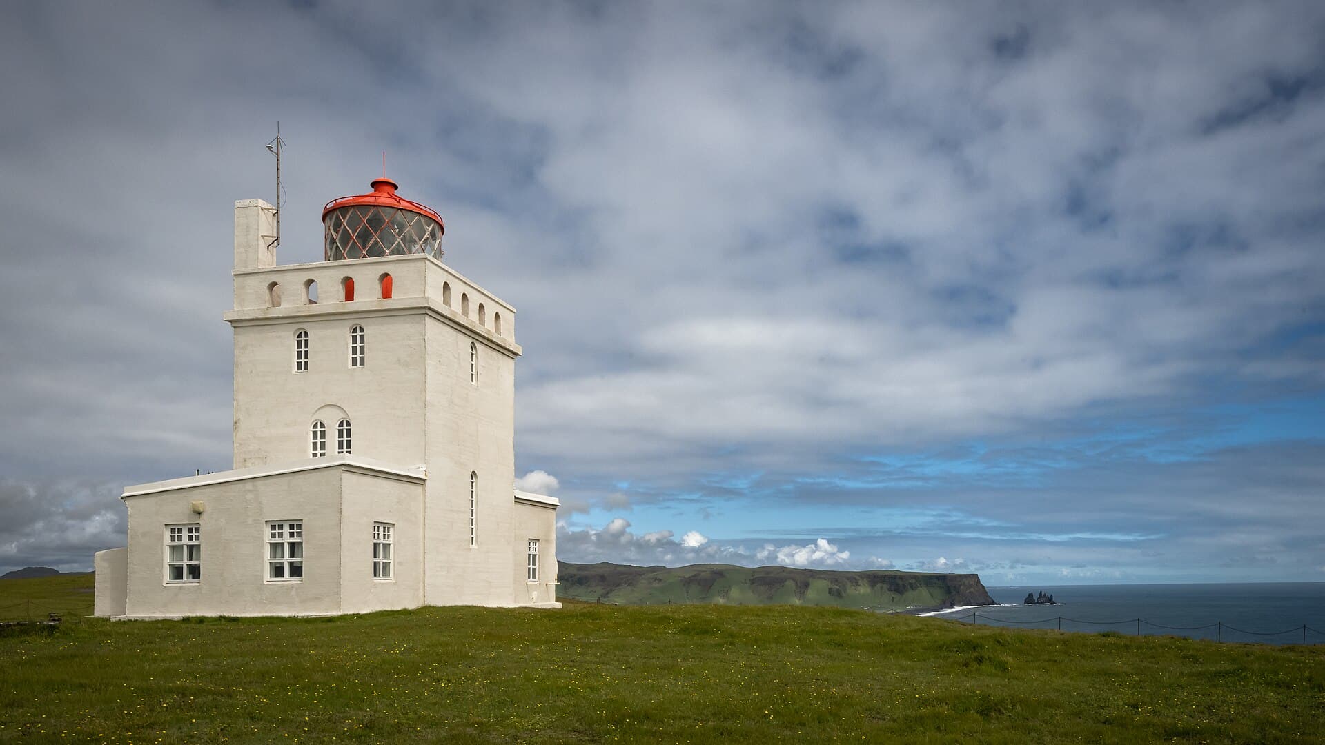
Dyrhólaey Lighthouse
Built in 1927, this striking red and white lighthouse crowns Iceland's southernmost cliff at 120 metres elevation. The view across the black sand plain between Vík and Dyrhólaey ranks among the south coast's finest.
 2Wikimedia Commons · CC BY 2.0
Landmark
Hjörleifshöfði Headland
An isolated promontory on the black sand plain of Mýrdalssandur, a former volcanic island now surrounded by ash desert. Hjörleifr Hróðmarsson, brother-in-law of Ingólfr Arnarson, was buried here in 874 – one of Iceland's earliest Viking settlement sites.
- 3
Landmark
Landmark
Vík Cemetery (Víkurkirkjugarður)
A small traditional Icelandic cemetery at the foot of the church hill, with graves dating to the 19th century. The place exudes profound tranquillity and offers an unusual perspective over the village and ocean – Icelanders maintain their cemeteries with remarkable care.
- 4
Landmark
Landmark
Reynisfjara Basalt Columns (Hálsanef Cave)
This hexagonal basalt cavern at the northern end of Reynisfjara forms a natural cathedral of breathtaking proportions. The perfectly regular columns appear hand-sculpted, yet they're the elegant result of lava cooling slowly over millions of years.
Religious sites
1 place
- 5
Religious site
Religious site
Church of Vík (Víkurkirkja)
This charming white chapel perches on Víkurfjall hill – the village's iconic silhouette. Built in 1934, it historically served as a refuge during Katla eruptions. The ten-minute climb from the village rewards you with spectacular views.
Nature
5 places
 6Wikimedia Commons · CC BY-SA 3.0
Nature
Mýrdalsjökull Glacier
This 596 km² glacier covers Katla, one of Iceland's most active volcanoes. Accessible from Vík via the F232 track, it offers guided ice excursions with crampons. A timely reminder that you're exploring a living volcanic island.
 7Wikimedia Commons · CC BY-SA 4.0
Nature
Reynisdrangar Sea Stacks
These striking black basalt needles tower 66 metres above the ocean, said by legend to be trolls turned to stone by the sun. Photographed from the beach at sunset, they're utterly breathtaking.
 8Wikimedia Commons · CC BY 3.0
Nature
Sólheimajökull Glacier Tongue
A glacier tongue of Mýrdalsjökull reached on foot from a parking area on Route 221. Unlike busier glacier destinations, you can approach the moraine freely. The contrast between blue ice and black volcanic sand is mesmerising.
- 9
Nature
Nature
Þakgil Canyon Campsite
Wild camping hidden within a basaltic canyon, accessed via F-road from Vík. The volcanic rock walls shield you from Iceland's fierce winds and create a unique microclimate. Only a handful of insiders know of this gem, situated 18 km from the village.
- 10
Nature
Nature
Reynisfjall Mountain Trail
A hiking route ascending Reynisfjall (340m) from Reynisfjara. From the summit, commanding views extend to Vík on one side and puffin cliffs on the other. Quieter in early morning, this is where locals come for sunrise.
Viewpoints
5 places
 11Wikimedia Commons · CC BY-SA 4.0
Viewpoint
Dyrhólaey Peninsula
A volcanic promontory featuring a natural arch large enough for an aeroplane to pass through – which it did in 1993. The lighthouse at the summit commands a full 360° view of the south coast and Mýrdalsjökull. Closed during puffin nesting season.
- 12
Viewpoint
Viewpoint
Mýrdalssandur Black Desert
A vast black volcanic sand desert east of Vík, regularly swept by jökulhlaups (glacial outburst floods) from Katla. Driving Route 1 at sunset with the glacier looming behind creates the uncanny sensation of traversing an alien world.
- 13
Viewpoint
Viewpoint
Route 215 towards Mýrdalur Valley
A minor, quiet road climbing Mýrdalur valley towards the interior. Traditional sheep farms, free-roaming Icelandic horses and views towards Katla make for a contemplative drive far from tour buses.
- 14
Viewpoint
Viewpoint
Northern Lights from Vík Beach
The absence of light pollution and the black sand beach in the foreground make Vík one of Iceland's finest spots for photographing the aurora. Between September and March, set up facing north with the Reynisdrangar sea stacks silhouetted against the sky.
- 15
Viewpoint
Viewpoint
Háaberg Viewpoint
A hidden gem of a viewpoint perched on the hillside behind Vík, offering a singular perspective across the village, the black sand plains and the Atlantic Ocean. Accessible via an unmarked trail from the local cemetery—locals can point the way.
Activities
3 places
 16Wikimedia Commons · CC BY-SA 4.0
Activity
Puffins of Reynisfjall (observation)
Between April and August, thousands of puffins nest in the Reynisfjall cliffs. Approach their burrows gently on the plateau above Reynisfjara – these endearingly clumsy and colourful birds tolerate visitors within metres.
- 17
Activity
Activity
Katla Ice Cave (departing Mýrdalsjökull)
An ice cave formed within the Katla glacier's depths, accessible only with a certified guide from Vík. The black ice, laden with volcanic ash, creates abstract patterns found nowhere else on Earth – no other ice cave compares to this one.
- 18
Activity
Activity
Katla Geopark Visitor Centre
The information hub for the Katla UNESCO Geopark, encompassing the entire volcanic region around Vík. Essential for understanding local geology before exploring further – local rangers offer invaluable advice on terrain conditions.
Beaches
1 place
 19Wikimedia Commons · CC BY-SA 4.0
Beach
Reynisfjara Black Sand Beach
Iceland's most dramatic black sand beach, distinguished by its hexagonal basalt columns and the Reynisdrangar rock formations rising from the Atlantic. The waves are treacherous – stay well away from the water.
More to discover
2 places
 20Wikimedia Commons · CC BY 2.0
Place
Vík í Mýrdal Village Center
Iceland's southernmost village, home to just 300 permanent residents. Wander along the main street, Víkurbraut, to experience authentic local life—a general store, petrol station and modest shops comprise the commercial heart of this intimate settlement.
- 21
Place
Place
Vík Wool Shop (Víkurprjón)
Authentic Icelandic wool boutique stocking lopapeysa (traditional sweaters) hand-knitted by local artisans. No industrial production here – each piece is unique and traceable to sheep in the region.
Also 🇮🇸 in Iceland